Greetings! This site has migrated to riversidesci.weebly.com -- please use that site for the most current information!
Oakland Tornado - June 3, 2014
The Forecast:
|
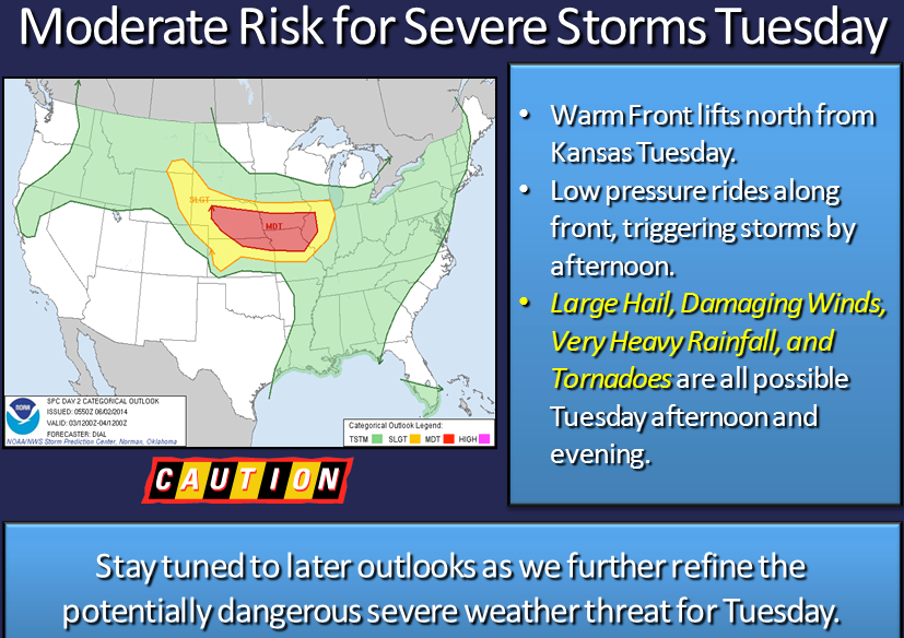
Saturday, May 31: The NWS announced the risk for severe weather in the Heartland on Tuesday. The phrase, "most powerful system so far this spring" was used by a meteorologist on the Omaha news.
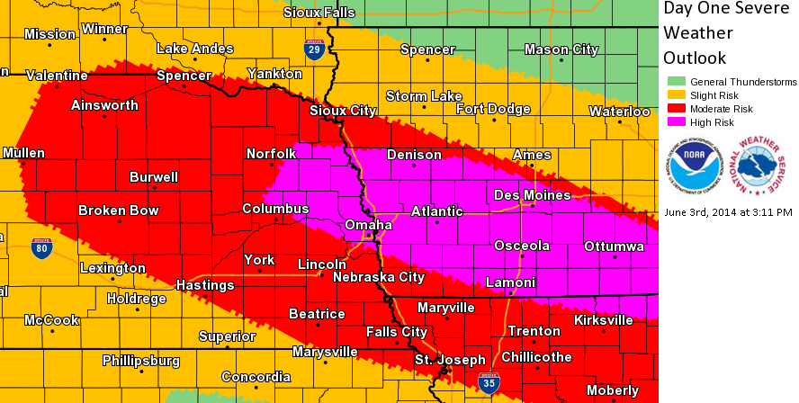
Monday, June 2: The NWS updated the severe risk map and used the terms large hail, damaging winds, very heavy rainfall, and tornadoes. Tuesday, June 3: In the early afternoon, the NWS once again updated the severe risk map. The storm risk in some areas, including Oakland, was elevated from the Moderate to the High Risk of Severe Weather category. Forecast from the Iowa Storm Chasing Network: Today you will want to be keeping a very close eye on the weather. A severe weather outbreak will take place later on this afternoon and on into the overnight hours. Severe weather will be likely from Nebraska, northern Kansas, Iowa, northern Missouri, and into Illinois. Storms will initiate out in Nebraska after 5 pm, and this is where the greatest tornado potential will be. While there is a tornado potential in Iowa, this potential will be lower as storms will form into one big line, making Iowa’s threat a damaging wind threat. The greatest tornado potential will exist from central to eastern Nebraska. As storms begin to line out, winds will begin to pick up with these storms. Straight-line wind gusts of up to 80 mph will be possible. These storms will also be producing heavy rain. Flash flooding is also possible, as rainfall totals could top three inches. Storms will begin to enter into western Iowa by 7 pm and will be in central Iowa by 9 pm. |

|
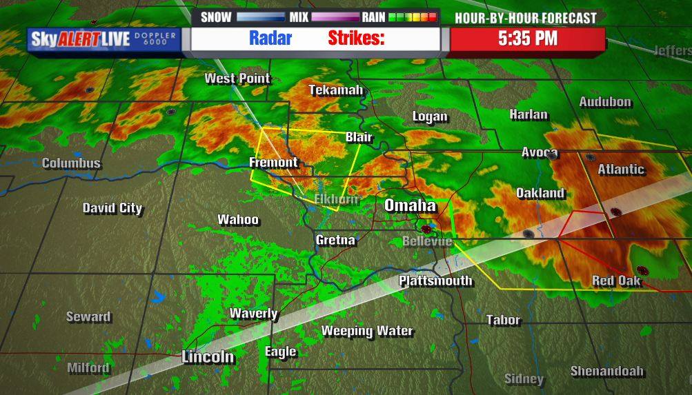
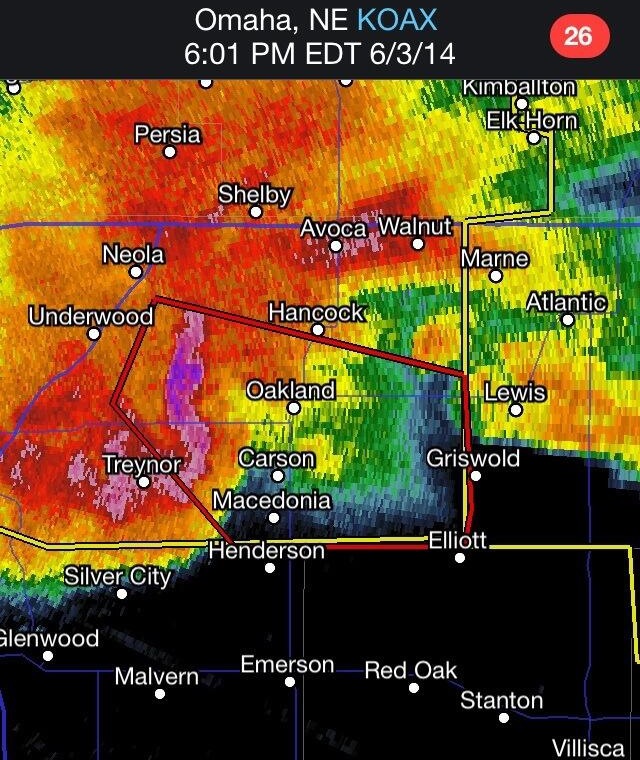
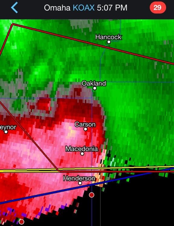
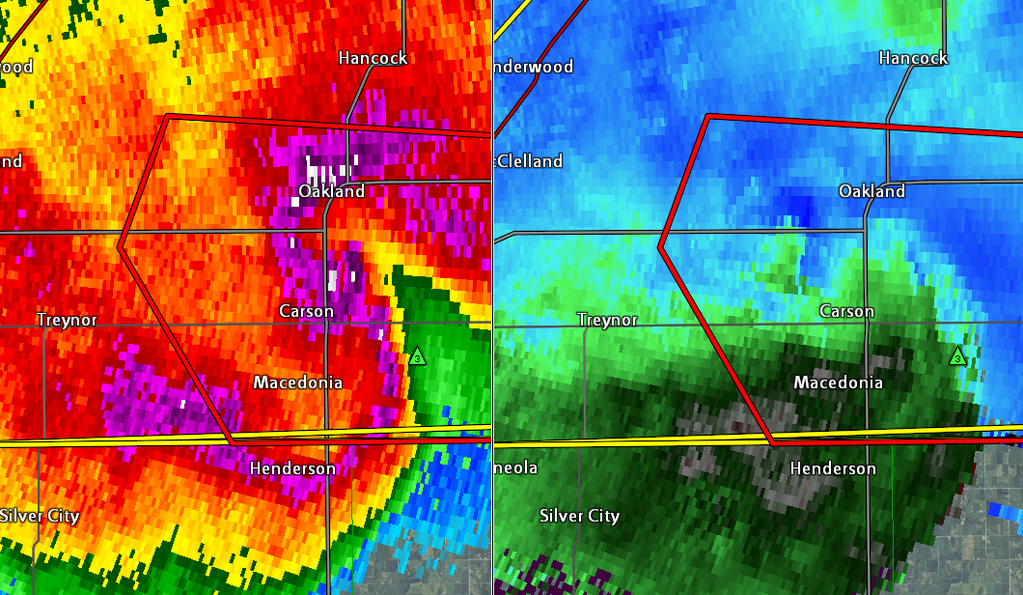
The Radar, Alert, and Relative Velocities:
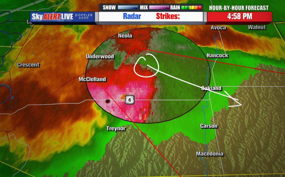
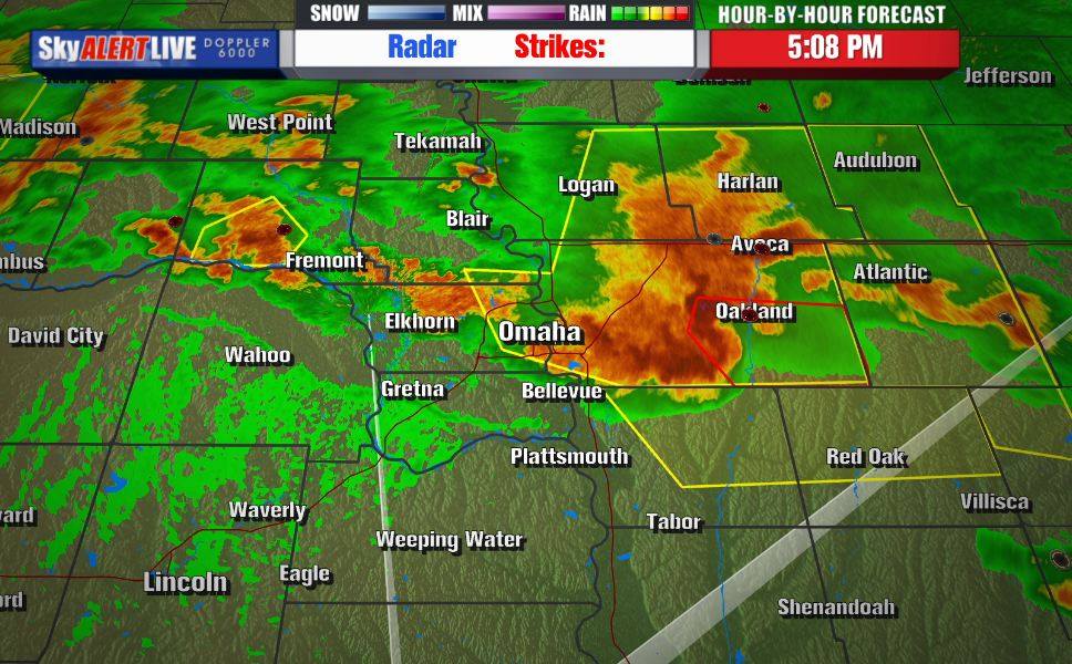
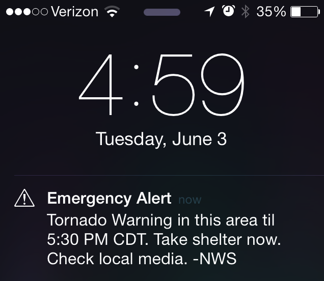
At 4:58 pm, the NWS issued a Tornado Warning for eastern Pottawattamie County. A possible Tornado was indicated by radar and relative velocity readings but it was likely to be rain-wrapped and therefore difficult to identify.


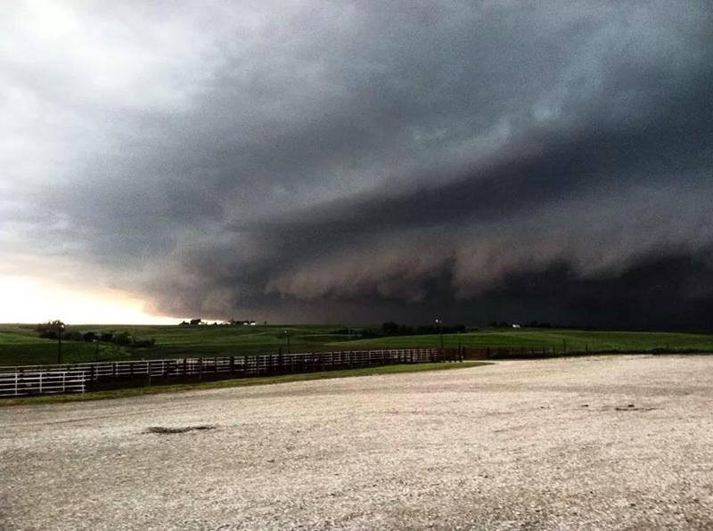
The Damage:
The most severe damage was to farms located approximately 5 to 8 miles west of Oakland. The storm hit Oakland at 5:13 pm and the worst of it lasted for a terrifying 5 minutes. The actual tornado dissipated before hitting town but Oakland did experience 100+ mph downbursts of wind, 4.5 inches of rain, and high-velocity hail. The damage around Oakland was similar to that from an EF-1 tornado but no storm rotation was indicated by the damage.
The NWS Damage Analysis Report:
The NWS Storm Survey Damage Team looked at damage around the Oakland, Iowa area. There was a large area of intense hail and wind damage across eastern Pottawattamie County. Wind exceeded 100 mph in some areas. Damages: a roof blown off a home, sheds and barns flattened, a four-mile stretch of high tension power poles bent, and numerous trees blown down. In addition, there were swaths of very large hail damage to homes and businesses. Within this swath of wind and hail damage a short-track tornado was detected.
Tornado Rating: EF-2
Estimated Peak Wind: 115 mph
Path Length: 2.9 miles
Maximum Path Width: 575 yards
This brief tornado started 8.25 miles west-northwest of Oakland by downing numerous trees. The tornado headed east-southeast and then hit a farm house and destroyed a garage, a barn, and severely damaged several other sheds. The tornado ended 5.75 miles west of Oakland and destroyed a farm shed and toppled numerous trees before dissipating.
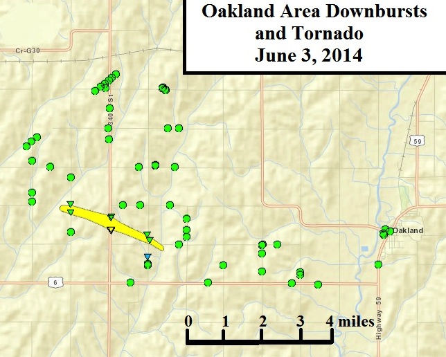
Yellow indicates the path of the Tornado and triangles are tornado damage.
Green dots are straight line wind damage at times exceeding 100 mph.
Tornado Rating: EF-2
Estimated Peak Wind: 115 mph
Path Length: 2.9 miles
Maximum Path Width: 575 yards
This brief tornado started 8.25 miles west-northwest of Oakland by downing numerous trees. The tornado headed east-southeast and then hit a farm house and destroyed a garage, a barn, and severely damaged several other sheds. The tornado ended 5.75 miles west of Oakland and destroyed a farm shed and toppled numerous trees before dissipating.
Yellow indicates the path of the Tornado and triangles are tornado damage.
Green dots are straight line wind damage at times exceeding 100 mph.
Discussion Questions:
|
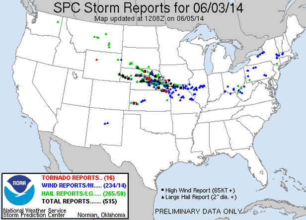
1. How do the forecast maps compare to the Storm Reports map shown on the right? Explain in detail.
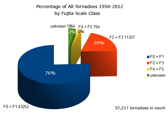
2. What was correct about the Iowa Storm Chasing Network forecast? What was incorrect? How would you rate the accuracy of the forecast? 3. What do you notice about the shape of the storm on radar and the radar velocities as it approaches Oakland? How does this relate to a typical tornado? Use this tutorial as a guide. 4. A Wireless Emergency Alert (WEA) for the Tornado Warning was sent to cell phones in the area. Read about WEAs here. How do you feel about the use of WEAs? What other emergencies do you think should result in a WEA? 5. The NWS rated the Oakland tornado as an EF-2 with a maximum wind speed of 115 mph. Did this rating come from direct or indirect measurements? How do you know? 6. Based on the pie chart on the right and information found here, what types of damages occur during the majority of tornadoes? 7. What steps should be taken to prepare for a storm like this? What materials should be readily available? Why? 8. Tornadoes are dangerous but what type of severe weather kills more people each year than all of the others combined? Do some research to support your answer. |
|
Learn more about Severe Weather and how to be prepared:
Thunderstorms, Tornadoes, Lightning: Nature's Most Violent Storms
Basic Disaster Supplies Kit
Prepare for Severe Weather
Safety during Tornado Clean-Up
NOVA: Tornadoes
Recognizing a Tornado on Doppler Radar
Thunderstorms, Tornadoes, Lightning: Nature's Most Violent Storms
Basic Disaster Supplies Kit
Prepare for Severe Weather
Safety during Tornado Clean-Up
NOVA: Tornadoes
Recognizing a Tornado on Doppler Radar